


information
- Apple Orchard Falls and Cornelius Creek Loop
- type: loop
- distance: 6.1 mi (listed at 5.6 mi)
- elevation change: 1578 ft (listed at 1680 ft)
- time: 3 hours with stops along the way
- location: Jefferson National Forrest near Arcadia, VA
- There are multiple ways you can do this loop including getting all the way up to the AT rather than taking the fire road connector and multiple trailheads to start at. My preferred trailhead is the trailhead at FS59 as described by hiking upwards in the link above. That way you do the climbing first before the downhills.
- On the loop, there are many stinging nettles, especially on the Cornelius Creek Trail and the fire road. So it is recommend to cover your legs in the summer.
report
Summer is actually my least favorite of the hiking seasons here in Southwest Virginia. The weather is generally hot, humid, and rainy. All you really see is a lot of green from the tree cover, which prevents you from some views as you hike up the hills here. However, there are hikes that I do enjoy in the summer, and those all usually involve running water of some sort. One of my favorites here in this area is the Apple Orchard Falls and Cornelius Creek Loop.
So we thought it would be a nice Sunday hike after a night of drinking. Our friends Matt and Brennan joined for the hike. Brennan is a new transplant here to Southwest Virginia and this is her first hike here. Kevin and Shannon tried to join us also, but they got lost as they tried to search for Apple Orchard Falls on Google. In light of that, to reach he trailhead on FS59, leave I-81 at exit 168 onto 614 to head south. Continue on 614 pass the James River and a set of railroad tracks as you enter the Jefferson National Forrest. Jennings Creek will start out on your left and shortly after it crosses to your right, you turn on FS59 right after an parking area. Follow FS59 along North Creek all the way to the turnabout at the trailhead, including a 2 mile stretch of gravel road that’s not on Google Maps. Alternatively you can park at Sunset Field on the Blue Ridge Parkway at MP 78.4 to start the loop at an alternative location.
In this report, I will outline my preferred route which starts with the uphills rather then end with it. Also, I prefer to hike up the Cornelius Creek Trail because you face the creek this way rather than the views being at your back.

There are a few crossings, where my I really appreciate my Chacos.

Also along the way are a few swimming holes that can help cool you off. If you want to have a nice dip at the end of your trek, then I’d recommend going clockwise form the same trailhead.
After a few miles following Cornelius Creek, the trail heads upward in it’s steepest climb of the day away from the creek. You will pass a camping site right before the steep portion. It is one of the many nice backcountry sites in this area. With one zig zag, we reached the fire road connector that we’ll take to the Apple Orchard Trail. At this juncture, there is an alternative route that will take you up to the Appalachian Trail. You can also take that route for the loop and meet up with the Apple Orchard Trail also. Lastly, there use to be a fire pit and another camping site here, but it is overgrown in the summer. Same can be said for the fire trail. Again, there are plenty of stinging nettles.

Along the overgrown bushes, you’ll also find wild blackberries.

After crossing a set of downed trees and a couple creeks, you’ll reach the junction for the Apple Orchard Trail. Head downhills by turning left. Along the way down, you’ll see many interesting rock faces. We predicted Kevin and Shannon talked about bouldering them when they pass it.

As you continue to descend, you’ll pass a set of wooden bridges with a cool little cascade, pool, and campsite. Perfect for doing some mid hike yoga.

Right before you reach the stairs where they is the rocky remains of a bench, the trees open up for a nice vista.

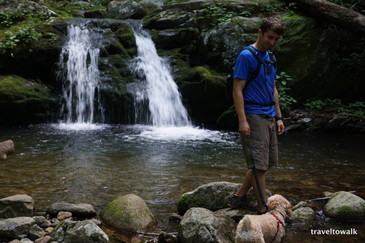
Before you head down the wooden stairs, you can head upwards on a faint trail just above the bench remains. This area is at the top of the falls and where a hidden campsite is located just across the creek. There is also a Geocache in the area, which is how I know about it. You can also get pretty close to the falls, so do be careful.
After the wooden stairs, you are at the bottom of the falls where there is a nice resting area. You can climb further up onto the rocks for a close look also.


After the falls, it is downhills on the Apple Orchard Trail.

The trail continues along North Creek passing several more campsites. When you come to a T junction, stay straight. After about 2 miles, you will reach Cornelius Creek again and the trailhead.
Make sure you check for ticks before heading out. The tall grass on the fire road and the optional bushwacking makes it likely for ticks to latch on.
ratings (1-5)
- views: 3. This is among my favorite hikes here in SW Virginia, mainly because we don’t see a lot of people on this trail typically and the amount of creeks you see on the loop. Lastly, a few swimming holes along Cornelius Creek is pretty awesome.
- difficulty: 2. It is generally a slow slopping uphill with a couple of steeper sections including some stairs downwards. However, not really too bad.
- technical: 1.5. Pretty clear for the most part, the fire road is pretty over grown and there is a section of downed trees you have to climb over. A few signs have been added there to help with directions and to show hikers how to hook up with the AT. There are blue blazes on the Cornelius Creek Trail and Apple Orchard Trail, but they are a bit faded.


pictures through the years


